T'Owd Man Trail Half Marathon
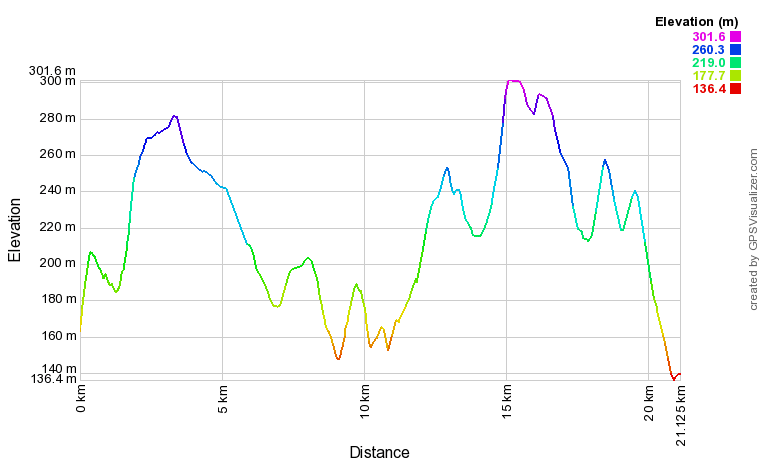
21.1km (13.1 miles) and 498m (1634ft) of ascentNew route from 2019. Still a tough ole boot of a race, but T’Owd Man is now a Half-Marathon!
Enter in advance to guarantee your place for £8 or pay on the day for £10. Over 18s only.
Places are limited to 300.
There is limited car parking at the Cricket Club, after which parking is available on surrounding roads. Please car share where possible.
The Route
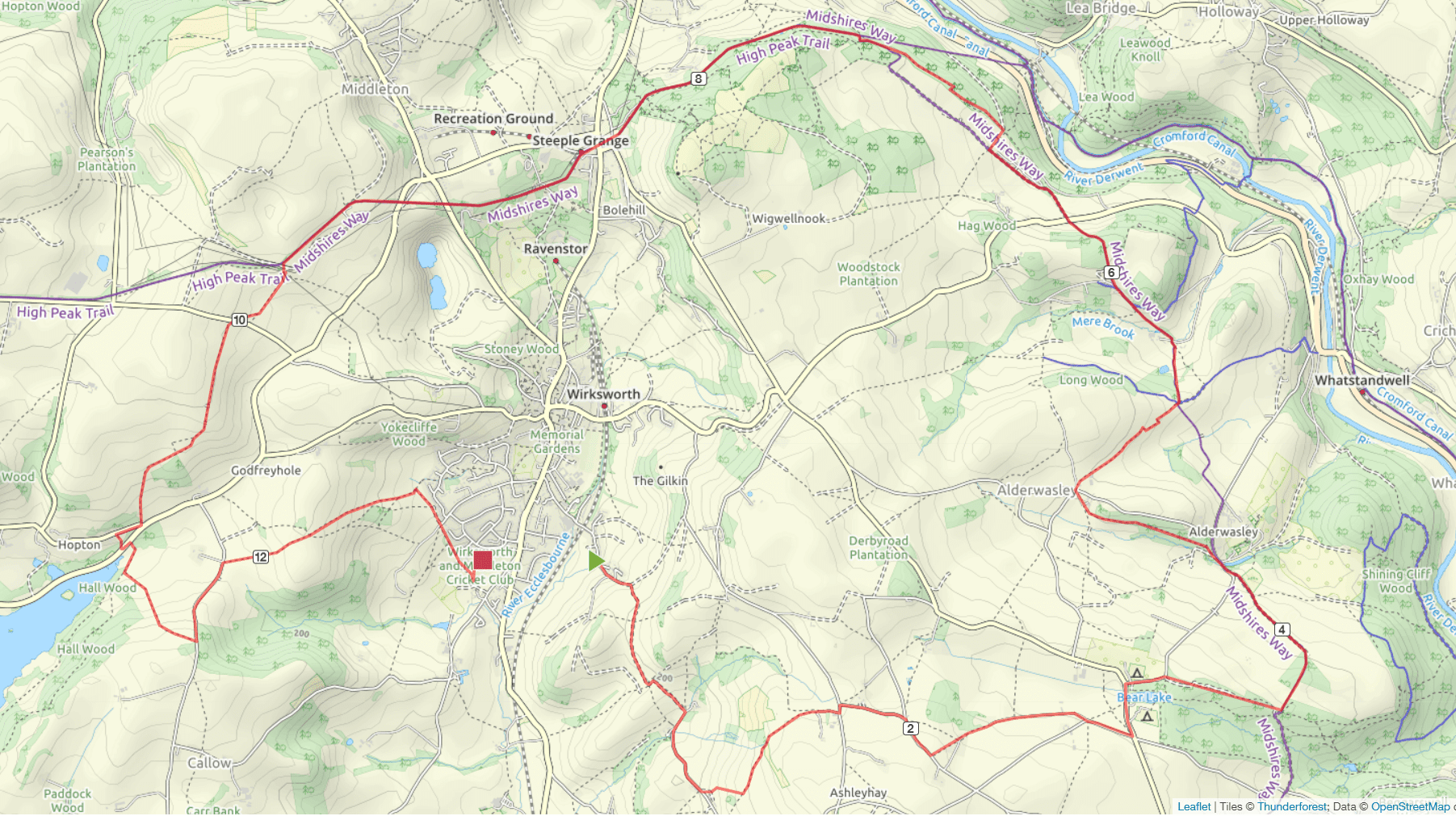
This is a Trail Running Association registered race, that starts and finishes in Wirksworth and is a hilly and varied route that follows paths, trails and some road in a beautiful loop around the town. You’re unlikely to endanger your PB, but we think this is one of the toughest and most scenic half-marathons around. Are you ready for the challenge?
For anyone who’s done the race before, you’ll notice a significant change at the end where we’ve replaced the tarmac finish with a sweeping descent over fields back into Wirksworth. We’ve also introduced some different paths through Peat Pits Wood and around Alderwasley and changed the entry point on to the High Peak Trail, so that you maintain height before the long drag up to Black Rocks Car Park and Middleton Top. There are now only two water stations, but the route remains well marked and marshalled throughout, so that navigation skills are unecessary.
You will be escorted from the registration point at the Cricket Club to the start at Gorsey Bank and this being Wirksworth, there is an immediate steep ascent, followed by a steady climb for close on two miles through stony lanes and fields until you get to a farm at Alport Lane. The actual 2 mile mark is reached after a flat bit of road (the first of two Knob Lane’s) which then gives way to more fields and tracks as you go past Clearsprings Farm, before briefly joining the Belper Road and heading down Higg Lane to enter Peat Pits Wood at around 5K.
This is the site of the first water station, and those of you familiar with David Denton’s races will recognise the next path which now stays high, before heading northwards through a gate and opening out on to the lovely grassy tracks (part of the Midshires Way) towards Alderwasley. As you descend into the village you very briefly re-join Higg Lane, before cutting off left into the trees and a path that takes in Kennel Wood and then once across the small road junction, a succession of fields with magnificent views across to Crich. When you reach the Five Way Marker, you descend steeply over fields as the route once again follows the Midshires Way and then climbs out of the valley past some houses and on a path through Crabtree Wood, before crossing the B5035 and heading down towards Birchwood Campsite.
You have passed the 6 mile stage by now and when you leave the track to cross the campsite field you come across the third change to the previous route when entering Shining Cliff Woods. Instead of losing height, we stay on the upper path until it descends and then climbs to avoid the tunnel, at which point you start the long ascent up the High Peak Trail in the direction of Black Rocks. Continue past the car park and before the trail rises again to take in the next Incline, the second water station will be reached by the National Stone Centre after nearly 9 miles of running.
This part of the course follows the route of the Wirksworth Incline, but once past Middleton Top you continue on the flat for a quarter of a mile or so before heading off cross county across fields in a southerly direction. Crossing a few stiles and a minor road, the course is undulating before it drops down in the direction of Hopton. Look for the flags in the ground here as you make your way round capped off lead mines. You are heading in the opposite direction from the route of the Undulator Race in October.
When you reach the road at about 11 miles, turn right towards Hopton but then follow the sign quickly left to the crossing point of the B5035 Ashbourne Road. This is the busiest road on the race, but visibility is good and once across you turn left to join the route around Carsington Water. You only follow this for 200m before a stile takes you up through some fields and a marshal will direct you through the gorse bushes onto Stainsborough Lane.
This year you turn left down the lane and when reaching Stainsborough Hall, a path to the right takes you up over some fields in the direction of Wirksworth. Follow the fields and cross the stony path and as you start the descent with the views opening up before you, you’ve got less than a mile to go. Marshals will usher you right as you reach the back gardens of the good folk who live around Yokecliffe and you follow the houses until a gap in the hedge takes you back into the Cricket Club and the finish.
Records
View all records on Web Scorer

If you are coming from afar to run in the race there are lots of options in the area including our sponsor, Mount Cook, a not-for-profit organisation based in Middleton-by-Wirksworth, which opened in July 2016. They offer en-suite accommodation for up to 184 guests in modern bedrooms and glamping pods, with catering facilities and a licensed bar provided in their glass-fronted Main Dining Hall.
A range of exciting outdoor activities, from High Ropes to Zip Wire, is also available at the Centre. If you are in need of any accommodation prior to a running event, please give Mount Cook a call on: 01629 823 702. For more information, visit their website.


